
South Dakota’s Best Roads to Ride During Sturgis Motorcycle Rally
Wildlife Loop Road
Custer, SD
The Wildlife Loop Road, while one of the roads on this list with fewer twists and turns, is still worth mentioning due to the beautiful scenery and wildlife experience. The twists and turns of the Wildlife Loop follow the prairie and ponderosa pine-speckled hills and take you through a highly populated area of the hills that feature buffalo and other wildlife. Take it slow and enjoy the 18-mile ride.
You should allow at least 45 minutes to drive the Custer State Park Wildlife Loop Road. Late evening, just before sunset, or early morning are the best times for viewing wildlife. Bison and prairie dogs can usually be seen throughout the day. Elk, antelope, coyote, and deer are not as likely to be out during the heat of a summer day. The wildlife is free roaming, and it is not very likely that every type of wildlife will be seen on every drive on the Custer State Park Wildlife Loop. This gives you the perfect excuse to come back time and time again. Different opportunities may present themselves at different times of the day and during different weather conditions to see the wide variety of wildlife that inhabit Custer State Park.
The Custer State Park Wildlife Station Visitor Center is located along the Custer State Park Wildlife Loop Road and has a map identifying where buffalo herds were spotted during the day. The Wildlife Loop Road has a network of well-maintained and easily traveled roads that lead off from the main paved Wildlife Loop Road. These roads provide access to more remote areas.
The 2017 Sturgis Motorcycle Rally kicks off August 3rd. We hope to see you there!
Courtesy of Sturgis Motorcycle Rally and Shooters Images
Vanocker Canyon
Sturgis, SD
Escape the craziness of town and head straight into Vanocker Canyon. The mouth to Vanocker Canyon is right at the edge of Sturgis, and following it will take you straight to a quaint little town called Nemo, which is always worth a stop. The winding roads take you through tree-lined valleys and narrow canyons. Follow the twists and turns through Nemo to Historic Deadwood for an afternoon break of sightseeing and gambling. Beginning at Sturgis Exit 32, off Interstate 90, Vanocker Canyon Road (Forest Service Road 26) winds southwest for 17 miles to Nemo. Large stands of birch and aspen provide a glowing backdrop along this peaceful and uncrowded paved byway.
Boulder Canyon
Deadwood, SD
The picturesque Boulder Canyon leads right in and out of Deadwood and is a quick and enjoyable ride. Boulder Canyon connects Deadwood and Sturgis and is 12 miles long, filled with curves that follow a stream as it winds through the canyon. At the end of the canyon it opens up, and the views through the hills are incredible as it takes you higher into Deadwood or lower into Sturgis.
This high-walled valley road (US Highway 14A) runs between legendary Sturgis and historic Deadwood, providing a brief but pretty 12-mile ride, with niches of colorful autumn views in the fall. It’s a relaxing lead-in to night of gambling and dining in Deadwood, or you can hop Interstate 90 at Sturgis Exit 30 for a quick run back to Rapid City.
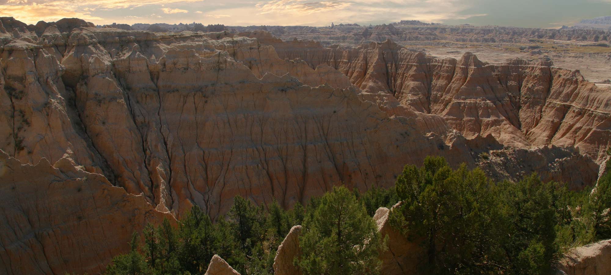
Welcome to the South Dakota Badlands.
Courtesy of Sturgis Motorcycle Rally and Shooters Images
Peter Norbeck Scenic Byway
Custer, SD
The Peter Norbeck Scenic Byway is the ultimate ride in the Black Hills to get a feel for what the area has to offer. More than 66 miles of twists, turns, switchbacks, and pigtails, this ride covers many of the other smaller rides that are available for motorcyclists.
The Peter Norbeck Scenic Byway includes a unique view of Mount Rushmore and the Wildlife Loop Road. This is the pinnacle of riding in the Black Hills and is a great taste for first-time Black Hills riders. The Peter Norbeck Scenic Byway consists of a loop made up of four numbered highways. The byway is part of US 16A, the Iron Mountain Road, south of Keystone. This portion of the highway includes several tunnels and pigtail bridges. The byway enters Custer State Park along its eastern edge and turns west at its intersection with SD 36. In the western part of the state park, the byway splits into two highways, one of which follows US 16A westward and one which follows SD 87 northward. The US 16A portion of the byway runs into Custer, where the byway becomes part of SD 89 and heads north. This portion of the byway meets the SD 87 portion in the northwest corner of Custer State Park. The byway then follows SD 87 to its intersection with US 16 and US 385, where it becomes part of the nearby SD 244. The byway follows SD 244 westward into the Mount Rushmore National Memorial, where it meets up with US 16A.
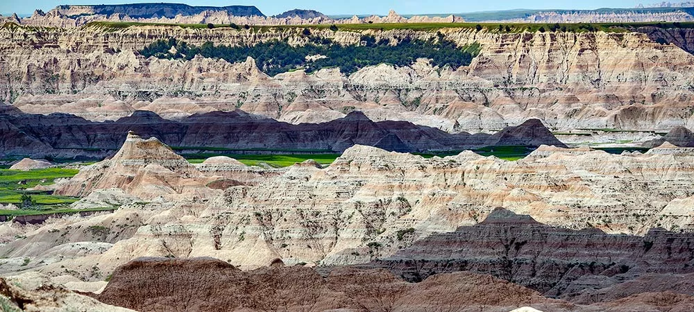
Another view of the Badlands. The rock formation almost looks like another planet.
Courtesy of Sturgis Motorcycle Rally and Shooters Images
Iron Mountain Road
Custer, SD
Iron Mountain Road is one of the most popular and favorite curving rides in the Black Hills. This 17-mile stretch of road is filled with not only curves but pigtails that force you to really slow down and enjoy the ride. This road is not for beginner riders but is a great way to learn how to handle curves. Iron Mountain Road is about a 45-minute ride and features 17 miles, 314 curves, 14 switchbacks, three pigtails, three tunnels, four presidents, and two splits. It is bookended by Custer State Park and Mount Rushmore National Monument.
Iron Mountain Road is a portion of US 16A. The route includes most of the tunnels on the South Dakota state highway system, including the only four-lane tunnel in the state, just north of Keystone. Part of the highway is also a boundary of the Black Elk Wilderness. The Iron Mountain portion of the road is not maintained in the winter. The road, like several other scenic roads in the Black Hills, was originally laid out by Governor Peter Norbeck, specifically to create a very scenic, slow-speed road for tourists. The section of US 16A from SD 89 to SD 244 is known as the Peter Norbeck Memorial Byway in honor of the governor. At the highest point of the byway, on the summit of Iron Mountain, there is a small memorial to Governor Norbeck.
Twists await riders in the Black Hills, too.
Courtesy of Sturgis Motorcycle Rally and Shooters Images
Spearfish Canyon Scenic Byway
Spearfish, SD
Spearfish Canyon is a beautiful drive anytime of year, but in the summer on a motorcycle is the best time by far. With 19 miles of twisting turns and winding road through a towering gorge of rock and trees, Spearfish Canyon offers not only great riding but also great scenery. Spearfish Canyon features three waterfalls throughout the ride that are well worth the stop to experience.
The 22-mile journey starts at Exit 10 off Interstate 90 in Spearfish, travels through its quaint business district, and connects to the mouth of the canyon at the Spearfish Canyon Country Club. From there, you’re looking at a run 20 miles upward through natural beauty and unique scenery, ending at Cheyenne Crossing at the intersection of Highway 85. Bonus Feature: Stop and enjoy the self-guided tour and interactive tour map presentations in the menu to the left, and the other special views of the canyon including photos, an aerial map, and an elevation map.
Needles Highway
Hill City, SD
Needles Highway is a local favorite for the hairpin turns and the needle-like rock formations throughout the road that give the highway its name. The road is littered with red granite towers of rock that reach through the trees and are certainly a sight to behold. This ride will test your riding ability. Be sure to be cautious when going through the two one-lane tunnels throughout the ride.
Leisurely Black Hills sweeps like this are great for a day’s motorcycle cruise.
Courtesy of Sturgis Motorcycle Rally and Shooters Images
Needles Highway is 14 miles long. Finished in 1922, the highway is named after the high granite “needles” it winds among. Access to the Needles Highway requires a Custer State Park entrance license, making that portion of SD 87 a toll road. Along this stretch lies the Black Hills Playhouse. The highway passes through two tunnels blasted through sheer granite walls—Iron Creek Tunnel and Needles Eye Tunnel. Owing to the narrow roadway, sharp turns, and low tunnels, the road has very little traffic. The vehicles that do travel this road are almost exclusively sightseers. Just after Needles Eye Tunnel, Highway 87 serves as the northern terminus of SD 89. After this junction, SD 87 has one more tunnel, Hood Tunnel. It then provides access to the Sylvan Lake Resort. The route finally ends at US 16/385 south of Hill City.


